Dec 12, 2022
How Will Winter Storm Affect St. Cloud and Central Minnesota?
By Zac Chapman / Assistant News Director
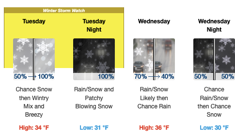
A mixed bag of precipitation is likely coming our way Tuesday with the best chance for accumulating snow in central Minnesota happening Thursday and Friday.
This forecast is from retired St. Cloud State University meteorology professor Bob Weisman who reports there are different precipitation scenarios for the upcoming storm. Weisman predicts the following:

- Light icing is possible at the start of the precipitation in most of central Minnesota with the potential for major ice accumulations in west central, southwestern and south central Minnesota, which could bring down branches and power lines Tuesday.
- Weisman’s best guess for St. Cloud is that we’ll have a chance for light icing midday Tuesday, then a mixed bag into Wednesday evening. There may be a light accumulation of slush or ice.
- The Twin Cities has a chance of light icing tomorrow, then a mix of mostly rain or freezing rain Tuesday evening.
- The major blizzard will be in North Dakota, central and western South Dakota, where travel becomes near impossible.
St. Cloud State sent out a campus-wide email saying it will makes every effort to announce any closing or cancellations by 5 a.m. each day regarding day classes and events and before 3 p.m. for evening classes and events. They’ll make decisions for the St. Cloud State at Plymouth by 6 a.m.
This week is finals week at the university, with fall commencement exercises Friday.
The primary method of communicating class closures or cancellations is campus-wide Star Alert emails and text messages, as well as notifications on the university’s homepage.


